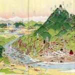
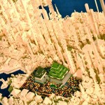
Talk about intersections between art and science! Now here’s some data that would look great on my wall. The Geological Survey Of Japan created these diagrams of volcanoes using colors to identify different rock units, ages and layers of lava. But to the untrained eye the organic shapes created by hundreds of thousands of years of fire and destruction are visually entertaining on their own.
Check out the GSJ website where you can see more maps and even order prints (prices range between 1,150 – 2,625 yen).

Miyake-jima
Type: stratovolcano
Last eruption: 2010
Summit elevation: 2,674 ft. (815 m.)

Aso
Type: caldera
Last eruption: 2011
Summit elevation: 5,223 ft. (1,592 m.)

Hokkaido Komagatake
Type: andesitic stratovolcano
Last eruption: 2000
Summit elevation: 3,711 ft. (1,131 m.)
source: wired